


February Wallpaper & Geotagging Photos


Hazratbal Shrine, Srinagar, Kashmir, India
[sdm_download id=”17072″ fancy=”0″ button_text=”Click here to download this wallpaper”]
Here is February’s wallpaper. Please feel free to download it or, if you have a Mac running Leopard, (and if it still works after loading the Leopard OS, LOL!!!) just click on it, then once it loads in the browser, ctrl click (aka right click) and you will have the option to make it your desktop image. I love Macs!
If you recall, I blogged my lust for the Jobo GPS device. I had hoped to use it for this next assignment in Sumatra. This is a small GPS gadget that fits on your camera and records the location of each image shot. But alas, Jobo informs me that there are some snags with production and that it will not be ready for this trip. As we say in India, “What to do?”
I knew Sony’s GPS device was also made to be used this way. So, I Googled, and found Terry White’s blog and review of it. Very helpful. But what I found even more helpful was some of the comments made by his readers (comments are good). Several insisted that any GPS device would work with as long as it can export a .gpx file. Any device? How about my Asus p353 cell phone? So after poking around on the net, I found some every cool and relatively cheap software called Beeline GPS for Pocket PCs. This will give my GPS the capability to record and export a track file. So it will run thoughout the day while I shoot. Note: the GPS device and the camera need to have their clocks synced as close as possible. At the end of the day shooting I take all my RAW (.crw) files, load them into a application called HoudahGeo. This is a really neat little application that grabs your images then loads the exported .gpx data and embeds this data into the EXIF data of the RAW file. Once you do this, you load the images into Lightroom as usual. But this time, in the EXIF data you will get a new pane that will show you the Latitude and longitude and a cool little link that you can push that takes you directly to Google Maps to see where the image was taken. Very fun and I hope it will be very useful for this next trip.

This is a quick sample image I shot of Scott & White Hospital here in Temple, TX.

This image shows the EXIF data in the Library panel in Lightroom. You can see the GPS coordinates listed under my name.

This image shows the EXIF data in the Library panel in Lightroom. You can see the GPS coordinates listed under my name.
 So, after you click on the coordinates in the panel, Lightroom opens up your browser and loads the Google map showing where you shot the image. Very Cool!
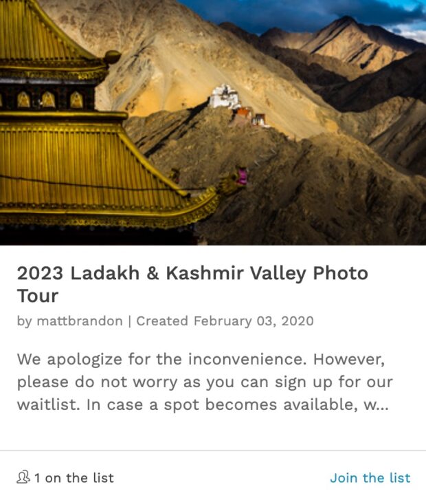
really lovely photograph, Matt.
t.
For the Windows users … right click the picture and “Set as background”.
Nice to know that the Macs finally added that functionality too.
Great post – – the picture is now my desktop image – – I appreciate the instructions.
Mac or Windows (I’m Mac), I always need the instructions.